Key Takeaways
- Press K in Eyes on the Solar System to enter or exit free-fly mode on a desktop or laptop.
- W, A, S, and D move the camera; Shift increases speed, while Q/E and Z/C add vertical movement and roll.
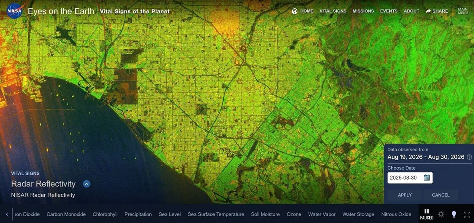
- Eyes on the Earth now shows a rolling 12-day NISAR radar-reflectivity map at 15 meters per pixel.
- The Mars view is a simulation and the Earth layer is radar data; neither should be read as a live photographic feed.
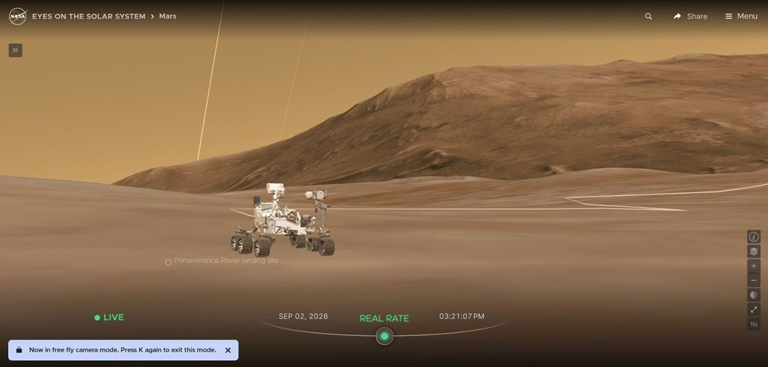
NASA’s Eyes now lets desktop and laptop users move freely across a full 3D representation of Mars. A separate update adds a NISAR radar map of Earth detailed enough to show individual cargo ships in major ports, according to NASA. Both are available through the agency’s browser-based visualization tools.
The September 3 release notes describe features delivered during August: Mars terrain and free flight arrived on August 4, and the NISAR map arrived on August 31. This is a guide to those available features, not a claim that NASA just started broadcasting live video from Mars.
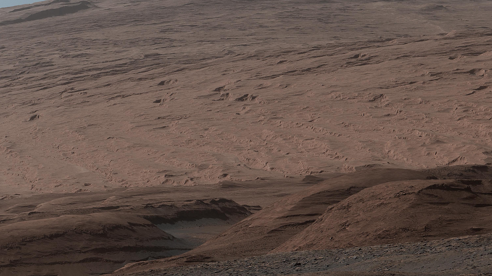
Hero photograph: NASA/JPL-Caltech/MSSS, Curiosity's Mount Sharp panorama from October 13, 2019; archival context, not an Eyes screenshot. Image source · NASA editorial reuse guidelines. NASA's white-balanced original, cropped and resized.
Start with the right Eyes application
NASA’s Eyes is a family of visualization tools. Eyes on the Solar System is the one for planets, moons, spacecraft, and moving around Mars. Eyes on the Earth is the one for the new NISAR layer. The similar names can make a feature seem missing if you open the wrong application.
NASA describes the tools as applications that run in a regular web browser. You do not need to turn a software installation into the first step of your exploration. The agency’s central Eyes page provides links to each application, including separate tools for asteroids and exoplanets.
For the new free-fly controls, use a desktop or laptop with a keyboard. The general Eyes suite supports browser-equipped devices, but the September instructions specifically describe desktop and laptop exploration for full Mars terrain. It would be a stretch to promise identical keyboard navigation on a phone.
NASA’s Solar System application also lets users move the simulation forward and backward in time. That makes it useful for understanding a spacecraft’s journey, but it means the date displayed in the application deserves attention. A historical or future view is not the spacecraft’s current position.
The keyboard shortcut changes how you explore
In the September release notes, NASA explains that pressing K enters free-fly mode from anywhere in Eyes on the Solar System. A message tells you the mode is active. Pressing K again exits it.
Use the mouse to click and drag the view until you are pointing where you want to travel. Then use the movement controls. The official instructions describe the following key groups:
| Control | What NASA says it does |
|---|---|
| K | Enter or exit free-fly mode |
| Mouse click and drag | Change the viewing direction |
| W, A, S, D | Move around |
| Shift plus a movement key | Move faster |
| Q and E | Move up and down |
| Z and C | Roll the camera view |
An easy first exercise is to separate looking from moving. Turn the view with the mouse, make a short movement, and look again before adding speed. That is our suggested learning sequence, not an additional NASA control or a claim that the app automatically guides your route.
Once comfortable, use the same mode elsewhere. NASA says free flight works anywhere in the simulated Solar System, at any time available in the application, and can reach the objects represented there. Mars is the most tangible new destination because full terrain gives you a surface to explore.
A useful way to compare a simulation with a photograph
The Mars feature provides freedom of viewpoint. A rover photograph provides a view captured by a physical camera. Those are different kinds of evidence, even when both help explain the same landscape.
The hero image on this article is an archival Curiosity panorama of Mount Sharp from October 13, 2019. NASA says that panorama combines 44 images and that the released version was white-balanced and brightened. It is included as a real view of Martian terrain, not as a photograph of the location shown in the new Eyes screenshot.
That comparison offers a useful exercise for students: label each image by its source, date, and type before discussing what it shows. The simulation can explain relative positions and let you explore a scene. The photograph records the surface from a particular viewpoint, with the processing described by its image team.
Free flight does not issue commands to a rover. You are changing a virtual camera’s position in a public visualization. Keep that distinction when sharing screenshots, especially if you choose a future date or a view no physical camera could occupy.
The NISAR layer is the other major update
Eyes on the Earth received a rolling 12-day radar-reflectivity map from NISAR on August 31. NASA calls its 15-meter-per-pixel resolution the highest of any dataset added to that application so far. That claim is specific to Eyes on the Earth; it is not a claim about every Earth-imaging system.
The distinction between resolution and update frequency is equally important. Fifteen meters per pixel describes the spatial scale of the displayed dataset. Twelve days describes the rolling coverage window. Neither number means that every place on the map is being observed at the same instant.
NASA says the view places the latest data on top. Its example shows southern California and individual cargo ships near the port of Long Beach. That is a useful starting point for understanding what the layer can reveal, rather than assuming every small bright feature can be confidently identified from the visualization alone.
NISAR is a joint NASA–Indian Space Research Organisation mission using synthetic aperture radar. The mission overview explains that it observes changes to land and ice using microwave signals and can work through clouds and darkness. The new Eyes layer exposes radar reflectivity; it should not be mistaken for every science product the mission can produce.
Roman’s trajectory and new places to visit
The August updates also added the Roman Space Telescope ahead of launch and updated its trajectory on launch day, August 30. NASA added the SOLAR-1 spacecraft and made the L1 and L2 Lagrange points available to visit in Eyes.
For readers who followed the launch, the useful next step is to inspect the trajectory while keeping the simulation date visible. Our Roman telescope explainer covers why reaching space and completing telescope checkout are separate milestones.
You can also pair an on-screen exploration with our September night-sky guide. A simulated close-up and a real observing opportunity answer different questions: what an object is doing in space, and what someone at a particular location can see.
What happens next
The features described here are available updates, so the immediate next step is simply to try the appropriate application. For Mars, learn free-fly movement before accelerating. For Earth, read the layer name, resolution, and coverage window before interpreting a feature.
NASA includes a step-by-step video tutorial in the release notes. That page is the best reference if a control behaves differently or the interface evolves. Future screenshots should retain enough date and layer context for another viewer to understand what they are seeing.
Quick poll
Which new Eyes feature would you try first?
Our take: keep the simulation date or map coverage window visible when sharing a screenshot.
FAQ
How do I activate free-fly mode?
On a desktop or laptop, press K in Eyes on the Solar System. Press K again to leave the mode.
Is the Mars view live rover footage?
No. Eyes is a 3D visualization using NASA data and imagery. Moving the camera changes the simulation view, not the rover’s cameras.
How detailed is the new NISAR map?
NASA describes a resolution of 15 meters per pixel and a rolling 12-day radar-reflectivity map in Eyes on the Earth.
Were these features released on September 3?
September 3 is the release-notes date. The Mars update arrived August 4, and the NISAR layer arrived August 31, according to NASA.